Travel Management Planning in Owyhee Canyonlands Part 2: Access, not Excess, in Canyonlands West
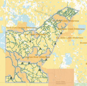
This blog is the second in a series about much-needed Travel Management in the Owyhee Canyonlands. The Owyhee Canyonlands are at continued risk from sprawling motorized use on an ever-increasing maze of user-created and redundant routes. The Bureau of Land Management (BLM) is taking public comments on an important travel management plan that would help address this issue. When conservationists, ranchers, sportsmen, river runners, dirt bikers, county officials, and others first came together to form the Owyhee Initiative in the early 2000s, updated Travel Management Plans were a key promise. The BLM has finally completed an inventory of existing routes and is now moving forward with much-needed travel management in the 677,000-acre Canyonlands West planning area. One alternative in particular, Alternative B, would do the best job of securing key access routes for the public and rehabilitating user-created and redundant routes which would improve habitat for sage-grouse, bighorn sheep, and other wildlife.  The Canyonlands West planning area is bounded by the Shoofly Road, Mud Flat Road and Juniper Mountain Road to the north, the Williams Northwest gas pipeline/Big Jacks Creek Wilderness boundary to the east, the Nevada Border to the south, and the Oregon Border to the west. The area includes parts of the Little Jacks Creek Wilderness, Pole Creek Wilderness, North Fork Wilderness, and Owyhee River Wilderness.
  The completed BLM inventory documented a mix of historic and user-created routes in the planning area totaling 1,309 miles – enough to drive from the Owyhee County seat of Murphy to Bonners Ferry - and back again! The BLM has put forward several travel management options for the Canyonlands West area. Alternative B is the most protective of wildlife and water quality and establishes 725 miles of routes, Alternative C has 941 miles, and Alternative D has 1098 miles and the highest number of routes within the sensitive Big Jacks Pronghorn migration route. Some of the proposed open routes include timing restrictions in specific areas to protect Greater sage-grouse in the spring (March 25-May 15, 5-9am) and seasonal closures for bighorn sheep lambing areas (April 15-June 15, 24-hours). We are asking ICL supporters to voice their support for Alternative B, which provides the maximum natural and cultural resource protection while consolidating motorized travel routes and rehabilitating redundant routes. Wildlife advocates are also encouraged to voice support for Alternative B.“Overall, Alternative B provides seasonal protection for Greater sage-grouse during critical life stages and would reduce current adverse impacts on breeding success and habitats necessary for winter survival. Additionally, fragmentation of crucial habitat would be reduced, along with potential for invasion of non-native species that may alter species composition and increase the risk of wildfire.” Canyonlands East EA p. 52. Pronghorn and bighorn sheep would also benefit the most from Alternative B than any other option. ICL will be meeting with other members of the Owyhee Initiative to get their perspectives on which trail system constitutes reasonable access and resource protections for the County, sportsmen, river runners, local ranchers, community members, and others and we may recommend additional changes to Alternative B. You can find more information on the BLM’s website here. Comments are due October 23, 2023 and can be submitted via the BLM National NEPA Register. For additional information, please contact Shannon Bassista or Bruce Schoeberl at 208-384-3300. Take Action at the link below – and thank you for speaking up for our Owyhee Canyonlands!


