Grand Views from Doyle Mountain: A proposal for the Grand View Travel Plan

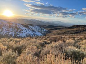
The crisp spring song of a Western meadowlark brought my attention to the bird perched on the sagebrush on the ridge to my left. Beyond it, a clear horizon stretched out before me. Other than the meadowlark and the low rusting sound of the wind through the sagebrush, the morning was completely silent and utterly peaceful—an all-too-rare experience in this day and age. I was hiking up a ridge toward Doyle Mountain, a wonderful, 6,161’ tall, non-technical peak with impressive 360 degree views of the surrounding peaks and undeveloped valleys with intact sagebrush steppe habitat. This morning’s lack of man-made sounds stood in stark contrast to other experiences in recent days while traveling through the maze of motorized trails in the Owyhee Front: the enthusiastic ‘braaaaps’ of dirt bikes in sand washes near Birch Creek, the eager revving of side-by-sides at trailheads off of Highway 78, and the rattling of my own old Toyota 4Runner on the washboard road.Human-generated sounds dominate every part of our day. Even when recreating on our public lands, noise from motorized vehicles (including my own rattling truck), Air Force training jets, portable speakers, and RV generators often dominates over natural sounds. That’s why when we do have these moments of silence and serenity, they feel so special. But they are getting harder to come by. These moments—and the places that provide them—need our protection.Just as people and wildlife benefit from clear views of the night sky through Dark Sky designations where light pollution is thoughtfully managed, studies have shown that people and wildlife also benefit from natural sounds and the absence of human-generated noise pollution.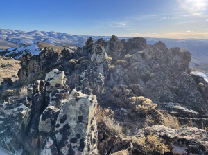 The Bureau of Land Management (BLM) is currently undertaking a travel plan for the Grand View area of Owyhee County. In this process, the BLM will determine which routes are open for motorized and mechanized vehicles, and which routes should be designated as non-motorized trails. The Grand View travel planning acre is 326,000 acres, and currently has no designated wilderness. The current density of motorized routes makes it almost impossible to be farther than one mile from a road or motorized trail. Despite this, the BLM is considering designating 784 or more motorized trails in the area, and out of the 1,365 miles of trails that were inventoried, the BLM is considering designating at most just 6 miles of non-motorized trails (<1%). That’s not balanced—and it doesn’t provide opportunities for the people who want to hike on a trail and hear nothing but the whistling sagebrush and the western meadowlark.
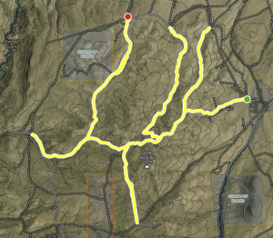 We have a unique opportunity to create a concentrated non-motorized, non-mechanized trail system in and around Doyle Mountain. ICL and others are proposing a 15-mile network of hiking and equestrian trails around Doyle Mountain where quiet recreationists can go and find a quality experience. This trail system would complement the surrounding motorized trail system and give equestrians, trail runners, hikers, backpackers, and hunters a highly desirable place to go; relieve pressure on other trails and trailheads; and keep these trails open to the public for maintenance and restoration funding, stewardship, and monitoring instead of being ignored and overlooked.These trails include both ridgelines and valley bottoms, which creates a natural soundscape for those who are seeking a unique quiet recreation opportunity. The BLM has already proposed designating a 1.7-mile long isolated section of non-motorized trail in the Doyle Mountain area, which would be the main trunk of this branching trail network—but that simply is not enough space for the many recreationists seeking non-motorized trails.We have found solutions like this before. The BLM recently designated 37 miles of trails in the Morley Nelson Birds of Prey National Conservation Area for hikers and equestrians along with 258 miles of motorized routes. Improved education and etiquette can go a long way to increase respect among all user groups, but trail runners, hikers, equestrians, and hunters often seek out non-motorized, non-mechanized trail systems and can be displaced by persistent motorized recreation. The same can be done for Doyle Mountain.
 There are other benefits for designating this as a non-motorized and non-mechanized trail system. Several trails up Doyle Mountain had been gullied out by multiple parallel sets of dirt bike tracks, some of which are over a foot deep. This damage seems to be related to the soil type and slope, not the riding style or route selection—so this damage would likely continue to persist as long as motorized use continues on these trails. This particular area is simply unsuited for this type of use.
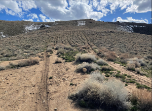
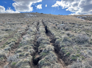 If the BLM designated this trail as non-motorized, non-mechanized, it would be possible to arrest the damage, restore these slopes over time, and bring in partners such as the Idaho Trails Association who have expertise in restoring eroded slopes and designing trails so they do not contribute to erosion. These partners are unlikely to come and fix these slopes if they remain open to motorized use and keep getting rutted out every weekend. There are likely other trail networks to the south in Pixley Basin that are currently in limbo and could be better suited for mountain biking. What’s more, a non-mechanized trail system for this area would help prevent conflicts between mountain bikers and equestrians, as some of the trails have blind corners.
 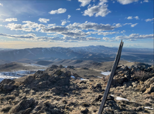 These designations would not displace motorized uses from this general area. Motorized recreationists would still be able to utilize hundreds of surrounding roads and trails, and those located in lower-elevation sand washes are far more suitable for single track motorized recreation. The BLM is not considering any non-motorized, mountain bike trails, but there are dozens of miles of potential trails nearby. Mountain bike enthusiasts could make their recommendations in surrounding areas for a better overall balance with the other users.The BLM wants and needs to hear from you about this plan. The window for public comments is open through April 15. Please express your support for Alternative B, the Conservation Alternative, and your particular support for designating the Doyle Mountain area as non-motorized, non-mechanized trail system. If you have special memories you’ve made in this area, please personalize your comments with them.Speaking up for balanced management of this special area will not just protect it today, but into the future. And you will be able to hear the Western meadowlarks like we used to be able to.